FergWorld : PIREPS : Cheap Bastard Wx (CBAV)

By Ryan Ferguson
** CBAV is no longer a viable tool, because Palm.net was terminated by PalmOne in September of 2004. Therefore, all that you're about to read is completely moot. Sorry. It was great while it lasted.
** Note: I have updated this PIREP as of July 15, 2002. Why? Because I think I was too harsh in my first review, and over the last 40 hours of flying I've slowly become more enamored of this highly economical and useful little tool.
The bottom line is that CBAV is an incredible bang for the buck, with limitations. With a $130 Palm Pilot and a $19.95 monthly subscription, you get NEXRAD weather data in the cockpit. You just can't beat that with a stick, folks. Frankly, it's right up there with "deal of the century" when it comes to aviation gear.
Thus, I have updated my rating and have upgraded my review of both CBAV and the Palm platform. I still believe that PDAs are not ideal for cockpit duties, but they can serve a very useful purpose within specified parameters.
Notations in red are updates to the original review.
| Pros: |
Very cheap way to get 'datalinked' weather in-flight |
| Cons: |
You get what you pay for |
| Bottom line: |
Combine it with a strikefinder for wx awareness |
| Rating: |
  Four stars (out of five)
 |
|
|
 Recently, I upgraded the panel of my Twin Comanche. I've only owned the plane for a year or so, but the old incarnation of the panel had to be at least a decade old. Not only was it visually unappealing, but it was really gasping its last few breaths of life. The Narco radios, although digital, faded in and out and suffered from severe static problems when flying through rain. The indicators were sticky; sometimes I had to thump my second nav indicator to encourage it to flip TO/FROM when crossing a navaid. My number one indicator's glideslope was inop. And, of course, I had no IFR-certified GPS of any kind, although my trusty Garmin 295 handheld had guided me right every time I used it. I knew getting a direct routing would save at least 10 minutes off of my trip time, and I really craved being able to shoot GPS approaches � many of the airports I frequent have no precision approach. I finally caved in and upgraded the panel.
"I flew the localizer approach into FQD down to minimums only once, and most of the weather that posed a threat was encountered during the enroute phase. I snuck in under the freezing level a couple of times, and my Stormscope provided tactical awareness for widely scattered convective activity on the few occasions we spotted it."
I viewed most of the upgrades as safety-related; new radios, new GPS, an electronic multi-probe engine monitoring system, and a second vacuum-powered attitude indicator. Aside from de-ice � well, and perhaps turbine engines -- my little twin was as safe as I could possibly make it for regular cross-country IFR duty. It featured freshly overhauled engines, new props, lots of maintenance and TLC, and of course I treated it very sweetly, making sure to give the nosecone a discreet kiss after each safe flight.
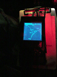
![New panel [loading]](pirep_cbav_panel_2.jpg)
Night-time picture of the new panel. Note the KLN-94 GPS and the
JPI EDM-760 engine analyzer (2 rows of orange bars monitoring EGTs and CHTS.)
You can just barely see the Palm VIIx display on the clipboard.
My wife and I fly semi-weekly to North Carolina to our little hideaway in the mountains. During the winter, we enjoyed generally decent weather on our aerial commute; I flew the localizer approach into FQD down to minimums only once, and most of the weather that posed a threat was encountered during the enroute phase. I snuck in under the freezing level a couple of times, and my Stormscope provided tactical awareness for widely scattered convective activity on the few occasions we spotted it. Other than that, the winter provided excellent flying weather with few challenges.
Since I fly in Florida, I knew it was only a matter of time before I again had to tangle with thunderstorms. Okay, 'tangle' is not really the right word; I'm fairly conservative when it comes to convective activity. However, if you want to fly with any sense of regularity over this great peninsula of ours (some call Florida "America's Wang") you will eventually have to pick your way around thunderstorms. I realized that, post-upgrade, I still had a big weakness: lack of big-picture weather awareness, and tactical avoidance capabilities. The last time I see NEXRAD weather imagery is nearly two hours before the wheels retract� sometimes longer. Flying north through the Jacksonville area, Florida's Thunderstorm Alley, I knew this was insufficient. Ideally I'd have weather radar on-board, but failing that, I wanted something that bridged the gap between the radar imagery I saw on my home computer and the "Picture is Worth 1,000 Words (literally)" approach of talking to FlightWatch.
So, I decided I'd investigate my options.
Option #1: Weather Radar
This one didn't take long to rule out. Overall, I think this is the best option available if you want tactical cell avoidance capability. As I've mentioned above, I wanted big picture awareness. If I had the money and the panel space to install weather radar, I would. The problem is one related to aircraft value. I've already got too many goodies in my Twinkie, and adding weather radar to a plane with no ice capabilities is just another nail in the coffin, so to speak. Hmm� maybe I should select a different analogy.
Option #2: Datalink Weather
I believe the future of aircraft weather avoidance lies in the datalink concept. Furthermore, I also believe we're all going to be flying behind an MFD (multi-function display) of some sort, some day. The concept is just too good, too logical, not to take firm hold. The IHAS (Integrated Hazard Avoidance System) from Bendix-King offers TCAS, terrain, weather, lightning strikes, and just about anything else you can dream up all on the same moving map display. That's a quantum leap forward, folks, and I want to be a part of it. But not yet. There are many players in the datalink market and the products have yet to mature to the point where I feel comfortable buying in. The price ain't exactly cheap, but it's not unreasonable, either. For under $20,000 you can have all of the aforementioned data output onto an MFD installed in your panel. Still too rich for my blood and specifically, my airplane; gotta keep moving on.
Option #3: AnyWhereMapWx
The AnywhereMap is a Compaq IPAQ hand-held computer with a color LCD display. It features a moving map display, along with most of the standard aviation GPS functions. The bonus is that the AnywhereMap now offers integrated weather data via a satellite link. And it does it all for a very reasonable price: the full package, which does not require any kind of special installation or approval, can be had for $3,000.
Of course, there's always a catch, and in this case the 'catch' is a big one. This system is an incredible kludge in the cockpit. In addition to the IPAQ, which you'd presumably mount on the yoke, you have to find room for a large array of equipment, including the 'sat-pack' (an integration module), a GPS receiver, a satellite phone, and an optional power back.
What this results in is a real mess of wires in the cockpit. I already plug in a handheld GPS (295) and a portable MP3 player, and that's enough cabling to deal with, thank you. My desire for an organized cockpit outstrips any perceived need I have for this product. Of course, you're also dealing with an interface with requires a stylus to fully use � try that in turbulence sometime!
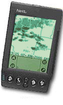
Option #4: Palm VIIx running CheapBastard Aviation Software
 I stumbled across this option when someone from the internet newsgroups suggested Cheap Bastard Aviation (CBAV, as it tends to be called.) This is a free Palm OS application that runs on a Palm VIIx hand-held computer using the Palm.net service. CBAV offers NEXRAD imagery, access to METARs, TAFs, and an N-number lookup.
The biggest problem with datalinked weather via 'cheap' means is the delivery mechanism. Palm.net coverage is not cellular based � they're basically just big pager towers that you can use to pick up a signal anywhere nearby, whether you're on the ground or in the air. While the Palm.net service is not really optimized or even intended for aerial use, it does work if there are stations nearby, and the word on the street was that it'd work even at 10,000+ feet. And it's also completely legal; no worries about trouble with the FCC.
The most attractive facet of taking this approach was the utterly inexpensive (relatively speaking) investment required to get up and running. All it took was a Palm VIIx, which can be gotten quite cheaply nowadays � I bought one from Amazon.com's marketplace for $130 � and the Palm.net service. The service costs $20 per month for a set amount of data transfer, and $40 for unlimited transfer.
I decided to give it a shot.
The Palm Pilot Pilot
Okay, let me make one thing clear. A PDA (a term which is interchangeable with 'hand-held computer') is NOT designed for use in the cockpit. I don't care how much you like these gadgets, you can't convince me that they have any place serving a critical role in the cockpit. It took only a couple of flights fidgeting with the device to really drive this point home. The concept of relying on an IPAQ for navigation is one that I find iffy at best. I would not rely on one of these gizmos for anything more than an augmentation of existing systems. I found using the stylus very difficult in-flight and in low-light and/or turbulent conditions.
With that said, here's a summation of the entire package and the major elements one has to deal with: the PDA Interface, the Palm VIIx itself, the Palm.net service, and the CBAV software. Incidentally, setting all of this up was extremely easy. I am reviewing multiple components of a whole, but the whole is contained within the single Palm unit, which I think is pretty cool.
|
The problem is truly the interface. The size of the PDA is small, and that is good for portability's sake. But without a better interface to input text, it's nearly useless in my opinion. When the air was smooth and the autopilot was engaged, I was able to easily use CBAV. If you have an autopilot, this isn't such a big deal, as it turns out. You only need to tap the screen a couple of times and then input a three letter VOR or airport identifier to center the unit around your present position.
So, that covers the interface nit. Note, I use this stuff enroute, and I routinely fly IFR... in fact I've filed IFR for every single cross country flight I've made in the last 10 months (and there have been quite a few of those.) So my use may not be the same as the VFR pilot going up on a sunny day. I want to use this specifically when weather is bad or deteriorating; the amount of time it takes out of my scan to get the information I want is pretty significant.
You might think with my complaints about the PDA interface that I'm also about to slam the Palm VIIx. Fact is, I like this little gizmo. I've come up with a number of applications for which having the PDA around is justified. Check palmflying.com for more free Palm applications. Again, the keyword here is value... we're talking FREE stuff here that ranges in utility from decent to pretty darn good. You can use a PDA for all sorts of useful aviation functions � just don't expect to be able to use one in the air at any given moment! Good applications include weight and balance, notes to use at your destination, emergency contact numbers, and so on. And, the price is right. About 130 Benjamins and you can own one. You can probably find one a little cheaper. I remember seeing these being sold for $350 or somesuch when they were first introduced.
The one thing I don't like is that the Palm VIIx uses two AAA batteries. They're good for a couple of weeks worth of use. A rechargeable lithium-ion battery would have been far preferable, but the issue was weight and expense. I can live with having to replace the batteries, but it isn't among the things I like about the VIIx. It's also easy to drain the batteries if the unit is wedged into your flight bag with some object depressing the "on" button. Has happened to me twice. Plus, if you have to put fresh batteries in after completely draining the Palm, the batteries must recharge the transmitter, which can take over an hour - just be aware.
The Palm VIIx has a decent backlight and it's easy to learn how to write using the Graffiti writing style. It took me about one-half hour to learn.
Palm.net coverage: I'm able to get a connection with the Palm VIIx about 60-70% of the time in the air. Oddly enough, in the Central Florida area I typically get no signal, then it picks up as I head north up to Jacksonville. Then I start losing it again in South Carolina. The main area I need the weather updates is near the east coast at the Florida-Georgia border, so I'm okay there. Coverage is decent, not great.
I'd say it's actually pretty decent, even pretty good in general in the southeast and northeast. I used it all the way from Central Florida to Montreal, Canada, recently, and only on several occasions did I have difficulty getting a connection. Here's another oddity - over the plains of Kansas, at 9,000 feet, I had fantastic coverage over nearly the entire state... go figure.
Palm.net's coverage map shows a notable deficiency of towers to the west of the Mississipi, so if you're a west coast pilot may not wish to consider the Palm.net service. For the record, Palm.net says they're adding new towers all the time. Click here for a coverage map.
|
Cheap Bastard Aviation Software (CBAV) |
The CBAV software itself is fine. Actually, it's about as good as you can get considering the limitations involved; the NEXRAD images have to be cropped based on the VOR or airport you enter for geographical reference, and they also have to be pared down to reasonable size for the sloowwww wireless data transfer. The big limitation here is that the Palm VIIx features a grey-scale screen. (Currently, all Palm-OS PDAs with built-in wireless functionality are grey-scale only.) There are only three levels of grey that can be used to display the intensity of weather in NEXRAD imagery.
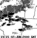 CBAV deals with this by breaking the levels of color into six modes. Mode 1 displays everything, including light rain, and Mode 6 shows only the heaviest activity. The modes in between let you piece together a weather picture by viewing the display one pane at a time. For more samples of what the NEXRAD data looks like in CBAV, click here.
If this sounds like a pain in the rump, it is. I've found that Mode 1 is effective for figuring out where the basic weather activity is taking place, then Mode 5 and 6 shows the areas you really need to stay away from. Problematically, this information is often at least 15-20 minutes old, and in some cases by the time you view it, you're seeing imagery that's a full half-hour out of date. This makes the CBAV app useful only for big-picture situational awareness, which may be good enough depending on your application. There is no tactical information which you can derive with this application, nor did the designers intend for it to be used in that manner.
Yeah, definitely not -- 40 hours later, I still feel this is true. The bottom line is that for all of CBAV's features, there's only one that is indispensible - it's the weather imagery. You can get METARs and TAFs from Flightwatch at nearly any point in the average cross country flight. And that text conveys all you need to know, so therefore it is not critical to get it via a wireless palm computer. But the weather imagery... ahhh, there is just no amount of words that can effectively convey what one CBAV image can give you. It's made all the difference in the world to me on several occasions so far.
|
The Verdict
I'm going to give a partial thumbs up here:
- Palm.net: 3 stars out of 5 for having 60% coverage in my area at altitude.
- Palm VIIx:
3 4 stars out of 5. Good PDA for the price. Very full-featured, and the integrated wireless access works very well. It needs a color screen and rechargeable batteries.
- The concept of using a PDA in the airplane:
1 2 stars out of 5. The interface is not geared for a cockpit work environment. But there are specific tasks for which the Palm Pilot can be utilized easily in-flight.
- CBAV software: 4 stars out of 5. It's free, so what more can you ask for? The main limitation is the lack of enough grey-scale levels to give a full NEXRAD picture. Nothing CBAV can do about that. The other real problem is the age of the imagery. Again, I don't know that there's much they can do about this, and I feel disinclined to punish them for it since they've offered the service free of charge to users. You have to bear in mind how mind-boggling even this level of in-flight weather awareness would have been to aviators of just a few decades ago. It's powerful stuff. Thanks, guys.
- Overall utility of the software/PDA/wireless service package for aviation applications:
2 3 stars of 5.
Questions or comments? Email me at ryan@fergworld.com. 
|